Irish Independent – WALK OF THE WEEK – Christopher Somerville
26 June 2010
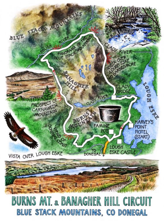
64. Burns Mountain and Banagher Hill circuit, Blue Stack Mountains, Co. Donegal

Is there a dreamier landscape, or name, than that of the Blue Stack Mountains? My God, Donegal people have scooped the lottery when it comes to walking country – a range of magnificently crumpled mountains reflected in the glassy, island-dotted waters of Lough Eske under a sky where golden eagles soar, a fine and friendly hotel at Harvey’s Point to admire it all from, and a guide as knowledgeable as Pat Murphy to winkle out the crabmeat of walking delights from the shell of a perfect day. Some folk have all the luck.
I felt pretty lucky myself, setting out from Harvey’s Point in company with Pat on a peerless blue morning – certainly luckier than the poor wretches who clustered round the Famine Pot in the 1840s. What a gulf lies between those days and these. The great iron cauldron with its thick spout stands in a display shelter by the roadside, not far from the spring where Quaker benefactors set it up to boil cornmeal stirabout for the feeding of five times five thousand starving people. A humbling image for the well-fed walker with bacon and eggs in his belly.
A country lane skirts the feet of Burns Mountain, rising gradually to reveal a wonderful view south-west to the Sligo mountains and the sandspits round Rossknowlagh and Ballyshannon, all pale blue today with the blur of heat and distance. We climbed a stony lane hemmed with dandelions, coltsfoot and the last remnants of the spring’s celandines. ‘Country medicine used to be based on the idea that a plant would benefit the thing it looked like,’ remarked Pat. ‘Celandines have these knobby roots, see? They put the English in mind of a bunch of haemorrhoids, so they called the celandine ‘pilewort’ and used it to cure piles. But the Irish thought it looked like a cow’s teats, so they’d hang it over the byre to bring on the milk.’
Mountain shapes pushed up along the skyline as we climbed – the round head of snow-streaked Binn an tSruthaill behind the petrified wave of Banagher, tent-shaped Carnaween across the deep Eglish valley. Locals still climb Carnaween on the first Sunday of June to say a prayer and cast a stone onto the summit cairn. In olden times, that was a sure-fire charm for meeting a sweetheart among folk ascending the peak from other valleys round about. The origin of the pilgrimage? ‘Oh, pagan sun worship and a chance to mix the gene pools,’ was Pat’s pragmatic guess.
What was that bird of prey high overhead? Peregrine? Buzzard? No – a golden eagle, a juvenile with white wing patches and broad ‘fingers’ of outer primary feathers, planing round in effortless circles. We stared up at the young eagle, rapt in admiration of its masterful, careless combination of power and grace, until it was a speck in the sun-hazed sky.
The beautiful and rugged Eglish valley, sealed in by towering ridges of schist and granite, runs into the heart of the Blue Stack Mountains. The Hamiltons, local landowners, were improving landlords who built handsome 2-storey houses along the valley for their tenants. The ruins of the cramped cabins they abandoned lie smothered in grass and heather on the slopes above the Eglish River.
Pat and I chose a stone each and sat absorbing our sandwiches and the view, with ecstatically singing larks for a choir. Then it was up and on, climbing the stony track to a pass between black old turf banks. Up there we halted to take in yet another memorable prospect, a panorama over Lough Eske, laid out all its serpentine glory, its wooded banks rising through tumbled moorland to the lumpy heights of Croaghconnellagh overlooking the Barnesmore Gap. Beyond rose Barnesmore itself, a pale whale of a mountain harpooned by white wind turbines. It was a view that had me enthralled all the way down to the lake shore.
WAY TO GO
MAP: OS of Ireland 1:50,000 Discovery 11
TRAVEL:
Bus (www.buseireann.ie) to Donegal town, then taxi (Michael Gallagher, 087-417-6600)
Road: From Donegal Town, N15 Letterkenny road; Harvey’s Point Hotel signed left in 1 mile; follow to Harvey’s Point Hotel (OSI ref. G 966831)
WALK DIRECTIONS: Left from Harvey’s Point. At T-junction, turn right and cross road to see Famine Pot in stone shed. Return to T-junction; keep ahead; right opposite Lough Eske Castle gate, up lane for 2 miles. At 5-way split at summit of road (938827), with 3 gates in view, take middle track (ungated; uphill) for 2 miles. Down at T-junction of tracks (932857), left to metal gate and tarmac road (928860). Forward downhill for 100 yards; sharp right (Blue Stack Way ‘walking man’/WM fingerpost) along road. Follow WM for 3½ miles, over pass and down to road (959848). Right (WM) for ⅓ mile; cross Clady Bridge; left (WM) on lane to Harvey’s Point.
LENGTH: 10 miles: allow 4-5 hours
GRADE: Moderate
CONDITIONS: Good tracks, roads
RATINGS: 3 buggies on lakeside roads, 3 binoculars, 1 mountain slopes
DON’T MISS … !
• Famine Pot
• golden eagles of Eglish valley (if they’re there!)
• view over Lough Eske from the pass
REFRESHMENTS/ACCOMMODATION: Harvey’s Point Hotel, Lough Eske, Co. Donegal (074-972-2208; www.harveyspoint.com) – warm, welcoming, efficient; fabulous food!
GUIDED WALKS with Pat Murphy: arrange through hotel
WALKING in IRELAND: Walking tour operators, local walks including Discover Ireland’s National Loop Walks, walking festivals throughout Ireland: www.discoverireland.ie/walking.
INFORMATION:
Donegal Tourist Office: The Quay, Donegal (074-972-1148); www.donegaldirect.ie; www.irelandnorthwest.ie
csomerville@independent.ie