Irish Independent – WALK OF THE WEEK – Christopher Somerville
1 May 2010
57. Glendalough and Glenealo, Co. Wicklow

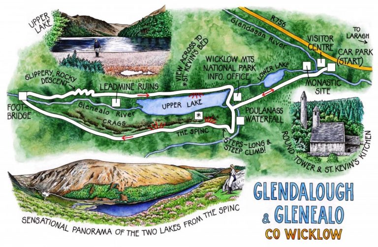
The rain-engorged Glenealo and Glendasan rivers were smashing their whitened heads together as they ran into one another in full fury. Standing on the footbridge below the monastic site at the mouth of Glendalough, Jane and I watched the struggling of the two rivers and heard the deep rumble of riverbed stones on the move.
The tall stone finger of the monastery’s Round Tower and the dark walls of its ancient churches rose beyond the confluence. The monks who built the hundred-foot-high Round Tower inserted a doorway three times the height of a man above the ground. An entrance far above the spear points of potential attackers, reached by a retractable ladder, was a necessity in the wild Dark Ages era when the tower was constructed – an era when marauding Vikings would burn a monastery and slaughter its monks as a matter of course. They did it to ‘Glendalough the Golden’ more than once.
When St Kevin first came to Glendalough early in the 6th century AD there was no whiff of monastic glory about the place. The uninhabited ‘Valley of the Two Lakes’, shadowy and ill-omened with dark crags hemming in two steel-black lakes, must have seemed the most forbidding place in the Kingdom of Leinster. That was precisely its appeal to Kevin, a fiercely ascetic, independent-minded and determined hermit of the most extreme rigour.
We followed the old pilgrim track called the Green Road along the south shore of the Lower Lake, a sheet of gunmetal in which the mountain slopes were hazily reflected. The sombre beauty of Glendalough slowly unfurled itself as the narrow valley swung to the right and revealed a perfect swoop of crags and mountain tops ahead. Tits and goldfinches were squeaking and flirting in the valley-bottom trees, but it was the dark silhouette of a big bird of prey, circling smoothly against the hurrying clouds, that held my gaze.
Poulanass Waterfall was a mighty succession of water sluices today, hurling itself down gleaming black chutes of rock. In the forest above, every heather sprig and spruce needle held a drop of yesterday’s rain. Our boots skidded and slipped on the railway sleeper steps as we climbed to the viewpoint at the very edge of the Spinc crags, head-spinningly high over Glendalough.
From here, a thousand feet above the valley floor, the Lower Lake seemed a ragged-edged pewter disk embedded in dark trees. Opposite, outcrops of mica schist in the cliffs of the valley flank rippled like flesh. As we walked on along the boardwalk the Upper Lake appeared, a broad bar of indigo whose western end lay scarred with pale mounds of quartz spoil left by 19th-century lead miners and smelters. The blue-lipped, emphysemic labourers of the Upper Lake, forgotten in their wilderness, lived as hard and unregarded as any hermit saint.
Once over the crest of the Spinc the boardwalk began a gentle descent that ended above the brawling water of the Glenealo River in the hanging valley beyond the Upper Lake. The river raced through this bleakly beautiful upland to tumble 500 feet into Glendalough in rainy spate. We got across by the footbridge, then skeltered down the zigzag track cut by the miners to reach their levels in the upper glen. The old smelting mill lay in ruins at the foot of the falls, where we sloshed through several rivulets to gain the path back down through the valley.
Glancing across the Upper Lake as we walked the homeward track, we made out the black mouth of St Kevin’s Bed, a tiny cave precariously high in a north-facing rock face where the self-denying hermit would watch and pray. The gloomy niche lies permanently in shadow all through the long months of winter. But this evening it looked out on a view of water and hill slopes illuminated by late sunshine from the south and west, gloriously lighting lake, forest and mountainside.
WAY TO GO
MAPs: OS of Ireland 1:50,000 Discovery 56, or 1:25,000 Glendalough & Glenmalure (widely available locally); Glendalough site and trails map (from Wicklow Mountains National Park Information Office, Upper Lake car park); downloadable map/instructions (highly recommended) at www.discoverireland.ie/walking.
TRAVEL:
Train (www.irishrail.ie) to Rathdrum (10 miles)
Bus (www.glendaloughbus.com): St Kevin’s Bus daily from Dublin
Road: From Dublin – M50 Jct 12; R115 to Laragh; right to car park at Glendalough Visitor Centre.
WALK DIRECTIONS: From Visitor Centre, follow yellow ‘walking man’/WM waymarks across river; turn right (‘Green Road to Upper Lake’) past monastery, to Wicklow Mountains National Park Information Office between lakes. 50 yards past office, left over stream (‘Poulanass Waterfall’). Follow yellow arrows up by Poulanass fall, and on up Wicklow Way. Where it turns left across river, bear right (white arrow/WA). On 2nd bend, right (WA), up steep stepped path through trees. At top follow WA along Spinc cliffs and into Glenealo. Cross footbridge; right; steep rocky path down to Upper Lake; follow paths back to car park.
LENGTH: 8½ miles: allow 4 hours
GRADE: Hard
BUGGY-FRIENDLY: Lakeside paths
CONDITIONS: Very steep ascent to cliff path; steep rocky descent to Upper Lake
DON’T MISS … !
• Glendalough Monastery
• view down lakes from Spinc cliffs
• St Kevin’s Bed
REFRESHMENTS: Plenty around Glendalough; picnic on Spinc cliffs
WALKING in IRELAND: Walking tour operators, local walks including Discover Ireland’s National Loop Walks, walking festivals throughout Ireland: www.discoverireland.ie/walking.
• Ballyhoura International Walking Festival, Co Limerick, 1 – 3 May: http://www.ballyhouracountry.com/events
• Dunmore East Walking Weekend, Waterford: 21-23 May 2010 (www.dunmorewalks.com)
• Midlands Walking Festival, Westmeath: 7-9 May 2010 (brian@walkingireland.ie)
INFORMATION:
Glendalough Visitor Centre: 0404-45352; www.glendalough.ie
csomerville@independent.ie