Irish Independent – WALK OF THE WEEK – Christopher Somerville
17 April 2010
55. Mount Stewart and Strangford Lough, Co. Down

‘You’ve got to do it,’ urged David Thompson, National Trust warden on Strangford Lough, over the phone. ‘You’ll kick yourself if you don’t!’
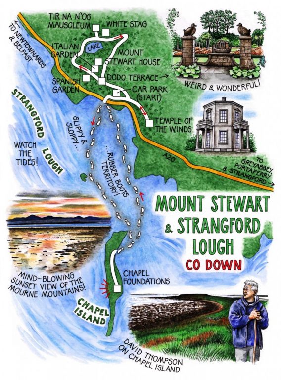
That kind of advice needs to be heeded – which is why Jane and I found ourselves on a blowy afternoon, rubber boots on and biblical-looking wooden staves in hand, squelching in David’s company from the gates of Mount Stewart out across the muddy bed of Strangford Lough towards the distant hump of Chapel Island.
Earlier in the day the three of us had been lucky enough to be shown over the wonderful Mount Stewart gardens by the Head Gardener. Philip Rollinson. There is a man with a profound feeling for trees and plants, a prerequisite for looking after gardens as exotic – and as quixotic – as those laid out by Edith, Lady Londonderry from 1921 onwards around her Mount Stewart residence.
Edith, wife of the 7th Marquess of Londonderry, was a serious plantswoman, but she was also a socialite, a heavyweight political hostess, a pioneer pilot, and a great lover of light and laughter. She abhorred Mount Stewart on her first visit there: ‘I thought the house and surroundings were the dampest, darkest and saddest place I had ever stayed in.’ How she worked to turn it all around! She devised Italian and Spanish gardens, lake walks and lily woods, and a sea garden with date palms and rhododendrons to keep at bay the eternal salt winds off the tidal lough. And she laid out the craziest of promenades, a Dodo Terrace bristling with stone carvings representing members of her ‘Ark Club’ of friends and colleagues – apes with cloven hooves, frogs and hedgehogs, and the dyspeptic-looking dodos themselves.
Above the lake we climbed a bank to Tir na n’Og, the walled mausoleum where Edith and her husband lie buried in elaborate sarcophagi. A milk-white stag in statue form roams the lawns beyond, symbol of hope and fantasy.
From the slender octagonal Temple of the Winds on its knoll we looked out across Strangford Lough. The tremulous pik! pik! of oystercatchers came up from the ebbing tideline where Chapel Island lay low and dark. ‘Time to go,’ decided David Thompson.
Who built the chapel out in the sea lough? History is silent, but it was probably a hermit monk from Movilla Abbey near Newtownards, some seeker after solitude. As we splashed and skidded through bladderweed hanks and drifts of cockle shells, I pictured him, a holy crazy with fishbones in his beard and a furnace for a spirit, trudging barefoot across the mud to the lonely tidal island to eke out a harsh existence and excoriate body and soul.
Pale-bellied brent geese were feeding on the wide mudflats, with a most beautiful skyline as a backdrop – Slieve Croob’s long back rising towards the south-west, and the multiple humps of the Mourne Mountains silhouetted down in the south against a lemon and silver sky, smeared over with an iridescence of petrol pink and blue.
We came ashore on Chapel Island across a beach of black and orange pebbles. A snipe leaped up from the grass and dashed zig-zagging away with a whirr of sickle-shaped wings. Up on the shaggy spine of the island we trod south, coming quite suddenly on the sunken foundations of the chapel. Oyster shells and cuttlebones lay like offerings on the shaped stones. ‘Whoever lived here wouldn’t have starved, that’s for sure,’ David said. ‘Oysters, shellfish, salmon; see the stone walls of the fish trap in the mud down there? Then the wild plants,’ – he swept a hand across island and distant shore – ‘sorrel, dulse, samphire, carrageen moss, sea beet. He might have been a wild man, but he wouldn’t have been a hungry one.’
The tide had slackened, and was beginning to gurgle back in through distant sandbanks further out in the lough. We shook ourselves back to reality and stepped down onto the mud. Plodding to shore in the half light I paused and looked back beyond Chapel Island, where the sun was slipping towards the upheld arms of the Mournes through a sky as red and raging as any fiery furnace.
WAY TO GO
MAP: OS of Northern Ireland 1:50,000 Discoverer 21; Mount Stewart garden map from NT shop; downloadable map/instructions (highly recommended) at www.walkni.com
TRAVEL:
Rail/bus (integrated website – www.nirailways.co.uk): Ulsterbus 10 (Belfast-Portaferry)
Road: A20 Newtownards-Portaferry
WALK DIRECTIONS: Make a circuit of the Mount Stewart gardens and grounds; then walk out across Strangford Lough at low tide to Chapel Island.
NB Tides and soft sands can make the Strangford Lough section dangerous. Only do this walk as part of a guided group – contact Mount Stewart (see below) or David Thompson (028-4488-1204) for details.
LENGTH: 5 miles: allow 3 hours
GRADE: Easy
CONDITIONS: Muddy across Strangford Lough – wellingtons/waterproof boots
DON’T MISS … !
• Dodo Terrace
• sensational skies and birds
• chapel remains
REFRESHMENTS: Bay Restaurant, Mount Stewart (024-4278-7805)
ACCOMMODATION: The Cuan Guest House, 4 The Square, Strangford BT30 7ND (024-4488-1222; www.thecuan.com) – delightful, comfortable and very friendly stopover
GUIDE BOOKS/LEAFLETS: From NT shop
MOUNT STEWART (National Trust): 024-4278-8387; www.nationaltrust.org.uk
INFORMATION: Walking tour operators, local walks including Discover Ireland’s National Loop Walks and Northern Ireland’s Quality Walks, walking festivals throughout Ireland: www.walkni.com; www.discoverireland.ie/walking
Upcoming Events:
• Ballyhoura International Walking Festival, Co Limerick, 1 – 3 May: http://www.ballyhouracountry.com/events
• Midlands Walking Festival, Westmeath: 7-9 May 2010 (brian@walkingireland.ie)
• Dunmore East Walking Weekend, Waterford: 21-23 May 2010 (www.dunmorewalks.com)
• Knockmealdown Crossing Mountain Challenge, Waterford/Tipperary: 24 April (www.peaksmcclonmel.ie)
Newtownards Tourist Office: Regent Street (024-9182-6846)
www.discovernorthernireland.com
csomerville@independent.ie