Irish Independent – WALK OF THE WEEK – Christopher Somerville
27 March 2010
52. Glenpatrick, Comeragh Mountains, Co. Waterford

A cold and windy day across the Comeragh Mountains in western County Waterford. But a winter warmer of a welcome for Jane and me in the tiny village of Rathgormack from enthusiastic hill walker Mick O’Donoghue and his friends and colleagues Catherine Flynn and Marie Cullinan, chairperson and secretary respectively of the superbly equipped Rathgormack Hiking Centre – a great example of what a small community can achieve with a bit of gumption and a lot of energy. A cup of tea and a bun or four, and we were ready to take the road in excellent company.
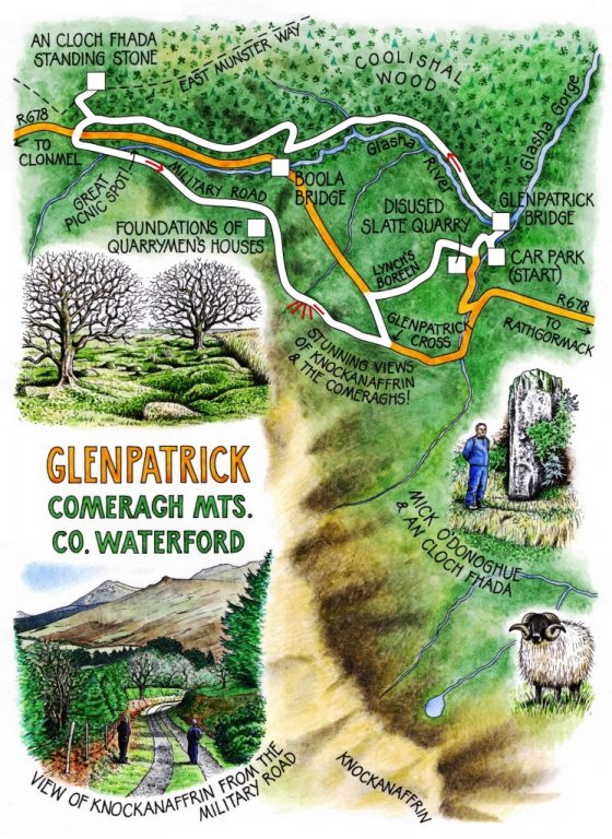
The Glasha River goes hissing and tumbling towards its meeting with the River Suir through a narrow gorge in the northern skirts of the Comeraghs. The five of us set off from Glenpatrick Bridge along the dark and ice-cold Glasha, following a forest track carpeted with leaves among the spruce, silver birch and hollies of Coolishal Wood. The river ran fast, with the pale green sheen of old bottle glass. In the still dank air under the trees, rotted trunks shone with a subtle phosphorescence. Marie and Catherine recounted great walks they’d revelled in all across Ireland; Mick spoke of the struggles of the Irish language and particular way of life in modern times. ‘Young lads – and you can’t blame them – prefer the English Premier League soccer to GAA. People need to know their own locality, but often they don’t. And their own culture, too! Walking your own hills and fields – that’s how to get in touch with it, I’d say.’
Above Boola Bridge Marie and Catherine powered on ahead and out of sight, while we lingered with Mick, looking back to a grand panorama of the Comeragh Mountains. ‘Carrignagower beyond The Gap, over on the left there,’ Mick recited, ‘the Rock of the Goats. Then Knockanaffrin in the middle – Mass Mountain – you couldn’t mistake the sharp peak of it, could you? And here ahead, Carrigsheegowna … hmm, that could be Carraig Sídhe Ghabhnaighe, the Rock of the Fairy Calves, or maybe that Sídhe is a Suí, the Rock of the Calves’ Seat … ?’
What brought Mick, Dungarvan born and bred, to his passion for the hills? ‘Yes, I was brought up a town boy, but we’d see Cruachan from Dungarvan, and it gave me a feel for the mountains. I just always wanted to be up there among them, and that was it for me.’
The forest paths led us to the East Munster Way, and a short detour to pay our respects to An Cloch Fhada, the Long Stone, a mighty standing stone stuck upright and resonant in a mossy bank. Then it was down and along the Military Road, a beautiful stony old way that ribboned across the hillsides. We grazed on Mick’s brown bread salmon sandwiches, and forged up through the heather to find the sunken house foundations of a band of long-forgotten quarrymen, their sheltering thorn trees hissing with wind, the loom of Knockanaffrin at their backs and the widespread vale of the Suir spread out before them like a feast.
Down in the valley once more, making for home against the wind, we met a mountain family coming along the road, mother in front with a crimson-cheeked toddler, daddy pedalling a skeleton cart behind, his knees up around his ears, hung about with chortling kiddies in Heidi hats. ‘Oh, a fine healthy day!’ he shouted as they all scooted past. ‘I’ve a good chance of getting there, I’d say!’
WAY TO GO
MAP: OS of Ireland 1:50,000 Discovery 75; downloadable map/instructions at www.discoverireland.ie/walking.
TRAVEL to Rathgormack Hiking Centre:
Rail (www.irishrail.ie): Carrick-on-Suir (6 miles). Bus (www.buseireann.ie): Deise Link (http://deiselink.ie/route1.shtml). Taxi: Paddy McGrath (051-646903). Road: On R678 between Carrick-on-Suir and Clonmel.
Travel from Rathgormack: R678 towards Clonmel for 3½ miles. Just beyond sharp left bend, right on minor road for 1 mile; car park on right (OS ref S 292197).
WALK DIRECTIONS: From car park, right along road (‘Glenpatrick Bridge Loop’/GBL green arrows). Cross Glasha River; left (GBL); past park, left (GBL) on forest road for 1 mile to R678 at Boola Bridge. Right up forest track (GBL); follow GBL for 1 mile to crossing; right (yellow ‘walking man’ waymark) up East Munster Way trail for 100 m to An Cloch Fhada longstone on left. Return to crossing; left for 200 m; right on stony path through trees (GBL). Cross R678; left along Military Road (detour right to miners’ house ruins: 273197) for 1¾ miles to Glenpatrick Cross. Left along R678 for 300 m (take care!); right (GBL) down Lynch’s Boreen to road; left to car park.
LENGTH: 5 miles: allow 2 hours
GRADE: Easy
DON’T MISS … !
• An Cloch Fhada longstone
• miners’ house ruins
• views of Knockanaffrin from Military Road
REFRESHMENTS: Picnic tables by bridge on Military Road
ACCOMMODATION: Rathgormack Hiking Centre (051-646969 or 640172);
www.rathgormackhostel.com)
WALKING in IRELAND: Walking tour operators, local walks including Discover Ireland’s National Loop Walks, walking festivals throughout Ireland: www.discoverireland.ie/walking.
Upcoming Events:
• Kerry Charity Challenge, Castlerosse Hotel, Killarney, 9-11 April: Climb Carrauntoohil with guide, walk Kerry Way, plenty more; proceeds to National Council for the Blind; contact Michael Sutton, 17 Willowmere Drive, Thurles (086-400-9989; michaelsutton1949@gmail.com)
• Tinahely Trail Walking Festival, Co Wicklow, 17-18 April 2010: www.tinahely.ie (email tinahelywalkerswelcome@eircom.net); tel 087-148-2468
• Ballyhoura International Walking Festival, Co Limerick, 1 – 3 May: http://www.ballyhouracountry.com/events
INFORMATION: Rathgormack Hiking Centre (see above)
csomerville@independent.ie